Adventure Rally
When I think of a rally, I think of an event where tons of people converge on one place to take part in a shared communal activity or some other kind of festivities, like Sturgis.
The idea of “racing through the European countryside in a car that is sliding around corners and jumping while local people are watching mere meters away” also comes to mind. Of course, it would not be a clear picture of you did not imagine the most famous rally in the world… Dakar!
Here in Japan, there are groups that have taken the spirit of riding in adventurous places and using a rally map to navigate the terrain and made it accessible to ordinary riders. I don’t know what the best name of it is but “Map Rally”, “Adventure Rally”, and “Touring Rally” all come to mind. I am certainly not the one who is going to coin it.
The rally map in Japan is called a 「コマ図」, or “koma zu.” They are several pages long and are typically cut and pasted together into a scroll. On your motorcycle, you need a map box to hold the map and allow you to scroll through it in order to follow it as you are riding.
Lets look at an example:
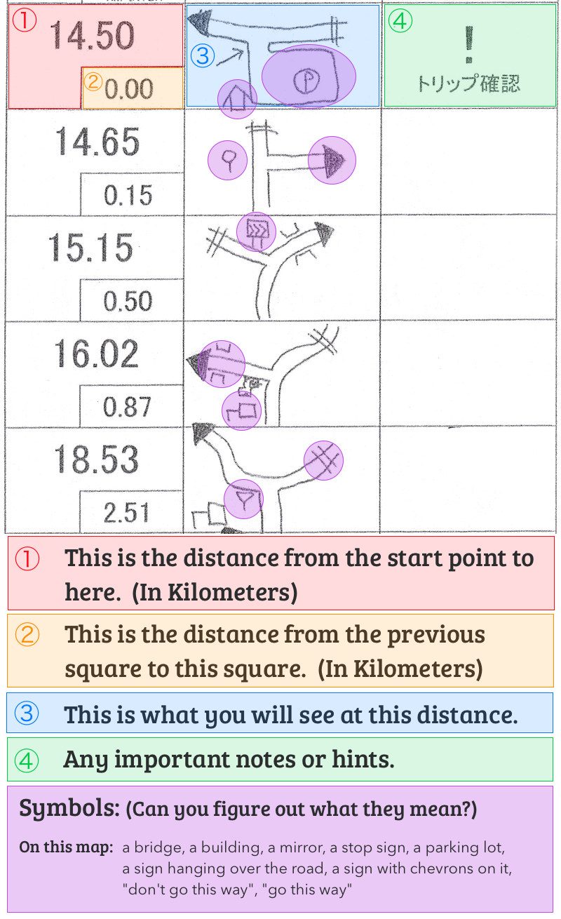
As you can see from the map, there are a lot of little detail that you need to pay attention to. Japan uses kilometers so the maps are in kilometers. It should be possible to do a rally with only your odometer on the bike or just a trip odometer but most people have either a “rally computer” or an odometer that can be adjusted, like the Trail Tech Endurance II.
I have tried maps made by several different groups and there are some symbols that you see over and over again. When you arrive at the point on the map, it often become clear what they were trying to represent. It does take a bit of practice and play to get used to them.
One other thing that is not mentioned in the video, or shown on this map is the use of a compass. To add to the difficulty, the map makers often add an illustration and a compass direction and it is up to you to figure out which way to go. I have been lost in groups of riders all trying to navigate their way through a compass section. It is fun!
At first glance, it seems like it’s a pretty easy, and maybe even boring, thing to do. Before I tried the first rally, I felt like “How hard can it be to follow the directions?” Man, was I wrong. The map makers build tricks into the map. Sometimes there are mistakes, sometimes I believe that they intentionally add small mistakes to keep you on your toes. A well designed map is a true joy to ride.
The event that I joined is called Door of Adventure. The website is only Japanese but can be found here: https://www.doorofadventure.com/
The events usually consist of about 20-30% of “dirt” riding. It is usually forestry roads. The roads most often are covered in stone and are pretty safe to ride. There were some spots that were pretty gnarly and rutted out so it might be difficult on road bikes. That being said, there are a lot of people that do it on little bikes like Cubs too.
Rallies can be all kind of distances but the ones I have seen range from 100 to 260 kilometers. They can take a long time to complete. In a recent rally, I rode 258 kilometers and it took a bit over 9 hours. I did stop to help other riders, stop for lunch and rode a bit more safely when I started getting tired. A lot of rallies also have check points. They want you to check in to make sure that everyone is still on course and safe. Some even have a “Quiz Point” to add to the fun, or a “View Point” to highlight a place with a great view if you want to rest or take a photo.
I hope that you can ride in an Adventure Rally one of these days! They are really fun!